MetSprite, a 21st century alternative to weather balloons
Atmospheric profiles taken by Radiosondes (weather balloons) are an essential component
of our Earth observation system. These observations are an integral part of the climate
record and essential for accurate forecasting. In recent decades, satellite platforms have
vastly increased the number of remote observations and thereby improved forecast skill.
Whilst satellite observations have excellent horizontal resolution, their vertical resolution is
poor and must be complemented by in-situ vertical profiling.
In-situ observations are typically performed by Radiosondes. However, their increasingly
high marginal cost (due increased cost of helium & labour) and the pollution inherent in
their operation has prevented the expansion of Radiosonde networks. Globally there are
800 Radiosonde sites launching twice per day, with the majority in the northern
hemisphere, and only 7 sites in the UK. Whilst advances in computing allow higher
resolution forecast models, the observations required to feed these models are struggling to
keep up.
The first few kilometres of the atmosphere, the planetary boundary layer, is where the
majority of human activity occurs, and where the weather is most complex and has the
highest socio-economic impact. It is therefore the most critical and challenging region for
observations. A data gap exists in the region above the ground observation network (≤10m)
and airliner cruise altitude (10km), which is currently only addressable by the sparse
radiosonde network.
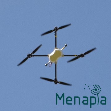
Menapia has developed MetSprite to address this data gap. MetSprite is a specialist
weather resistant drone with an inbuilt atmospheric sensor package (traceable calibration)
and an airframe optimised for vertical profiling. The increased payload and re-usability
allows multiple advanced sensing systems to be flown on MetSprite, such as for detection of
gases, aerosols, particulates and radiation. A profiling mission can be flown with the push of
a button on the web interface. An inbuilt parachute, autonomy and redundant systems
make it BVLOS ready, for remote operation and high altitudes.
MetSprite’s cost per profile is over an order of magnitude lower than a Radiosonde, whilst
achieving higher fidelity and a wider range of operating conditions. With a faster, more
efficient climb rate it can reach an altitude of over 10km (wind dependent). This range
allows it to capture the full planetary boundary layer at any point on Earth, and even reach
stratospheric heights at high latitudes. Unlike a Radiosonde, the ascent rate and position of
a MetSprite can be controlled, slowing down to capture fine details such as inversion layers.
By comparison, the ascent of a Radiosonde is uncontrolled and the first 300m is usually
discarded due to sensor settling time.
Initially MetSprite is offered to researchers exploring atmospheric phenomena in greater
detail. Soon after Menapia will release it’s DiaB solution for full pilotless operation, suitable
for integration in the observation networks of national meteorological organisations and
private forecasting companies.
Whilst Radiosondes still have the best peak altitude performance, they are out performed
by Menapia’s MetSprites on cost, sensing performance, spatial and temporal resolution. The
potential for the next step change in forecast skill is here.